ANYWAY, up and out too late for breakfast at The Salmon Bake so we backtrack down to Cantwell where we will head east on the Denali Highway. "Denali Highway"...really?... that is the official name for a 135 mile long road .... of which almost 24 miles is paved. Yup, 110 miles of gravel/dirt/mud road, open maybe 5 months a year, with a suggested top speed of 30 miles an hour - and that only in a few places - is a HIGHWAY ! Here is a third party description from www.dangerousroads.org
I agree with all of it except where it says, "...no stretches of mud."
"The Denali Highway (Alaska Route 8) is one of most scenic drives in the United States. With a length of 135 mi (217 km), this gravel road leads from Paxson on the Richardson Highway to Cantwell on the Parks Highway, in Alaska, USA. The road was opened in 1957.
The road's design, providing stunning panoramic views, is very curvy and fun for a leisurely ride. Of the 135 miles of the road, the first 21 miles on the eastern end, and first 2 miles on the western end, are paved. The rest of the road is gravel, not dirt, hence there effectively are no stretches of mud but there can be sharp rocks. The road is lightly traveled.
The weather on this zone is harsh and highly unpredictable and it does not take much time for the bright sun shine to change over to moderate to heavy snow fall. The highway is now little used and poorly maintained, and closed to all traffic from October to mid-May each year. Only the easternmost 21.3 miles (34.3 km) and westernmost 2.6 miles (4.2 km) are paved. A sudden drop in the temperature, even in summer, can trigger winter-like conditions.
Check weather forecasts before leaving home, and remember that it becomes cooler and often more prone to storms at higher elevations. The first 21 miles of the road are paved, and the entire 135 miles is two lanes wide. The route quickly climbs from the boreal forest to access the tundra and taiga along the foothills of the mighty Alaska Range. From the Paxson elevation of 2,750 ft., travelers eventually climb to the Maclaren Summit at 4,086 ft., the second highest road pass in Alaska. Many rental car companies will prohibit driving the Denali Highway, but a number of companies do allow travelers to take their cars on this road."
Before tackling it we stopped at JP's Coffee House a place that came highly recommended by locals for its meat pies. I've provided a link but the "Menu" tab is completely incomplete. They make whatever they feel like on any given day and put it on their white board.
Please note - a very popular spot on THE major North South highway in the state - in spite of the neon "OPEN" sign, there are NO POWER LINES. Propane for heat and cooking, generator for electric. Same for their house next door. People do have a different concept of "civilized living" up here.
That doesn't stop them from eating well though. Again I say, "Pictures don't do it justice." Fresh scrumptious fried dough, eggs, potatoes, bacon, ham, and goat cheese. Made to order and well worth the wait.
Now it's time to tackle the Denali Highway. We had been told to bring two spare tires. Fortunately Kris, like almost every Alaskan, has a set of four studded tires on wheels so it was easy to toss one of those into the back of the truck.
Miles and miles of ........miles and miles.
Those are snow covered mountains WAY off in the distance. But the near scenery is almost treeless tundra. It looks like beautiful grass from the road but a very sort hike off the road shows that it is waist to head high brush which will happily tear you to shreds if you try to make your way through it.
Travel through the tundra other than in winter defines the phrase "bushwhacking". Which is probably why most travel is on snow with dogs and sleds or snow machines (known as snow mobiles in the lower 48)
Not much wildlife viewing. A bird with long beak and long legs like a sandpiper. I'm pretty sure it wasn't but the tundra is very swampy and any low place becomes a pond so it would be at home here. In the summer.
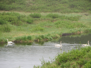
And trumpeter swans.
About 90 miles in we descended from the high tundra to MacLaren River.
The MacLaren River Lodge has been here since the mid-1950's and the current owners, Susie and Alan Echols took over in 2003 after many years of living in the area. Wonderful hosts, builders and chefs.
Here is the view as we came down the hill to the Lodge. The river is in the background. To the right is a small lake. Just to the left of center is our log cabin.
View from the porch
We got to talk with the owners while they took a break from the kitchen. They have three dogs that have the run of the place. Finn made friends with all three but Carol only got pictures of two.
We took a short hike to the top of the hill for these views
Finn is enjoying our trip too
Nice hike, big appetite. Question: "What kind of food can we expect when the nearest grocery store is 100 miles away. " Answer: "Fantastic". Real home cooking with a flair.
Burger with mushrooms, bacon and blue cheese. And a side of fresh cut fries.
But the real stars were the pies. Fresh Rhubarb and strawberry a la mode.
I asked about "fresh" so early in their season. Seems 20+ hours of daylight makes things grow really fast.
Not fresh, but wonderful mixed berry.
Not fresh or local but equally delicious french apple.
And they make the ice cream on the premises.
Next morning.
Tourists not like me required that the helicopter slinging loads wait until 7am to start. I checked, pilot was not a Whirly-Girl. A perfect use for a chopper - less than 60 miles to site but no roads of any kind.
Back to the main lodge for breakfast. Eggs, toast from fresh home baked bread and caribou sausage.
The 5 Musketeers.
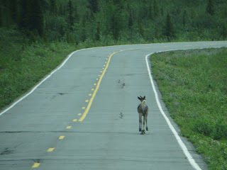
Headed on to civilization. But as soon as we reach the paved road we are reminded that we are in Alaska.
Don't know where his Mama is, but he's too young to be on the road by himself.
Next stop, McCarthy.


