Saturday, October 8, 2016

ARCHES NATIONAL PARK - DAY 2

Our "up and out early and avoid the crowds" is still working. We again went through the gate with no stopping. Literally. Because the attendant wasn't there yet. I'll admit it does take some of the fun out of it when we go in for free. I don't get to use my Geezer Pass and "save" $30.00.

Sunrise is as pretty as sunset.


But the color change is reversed.


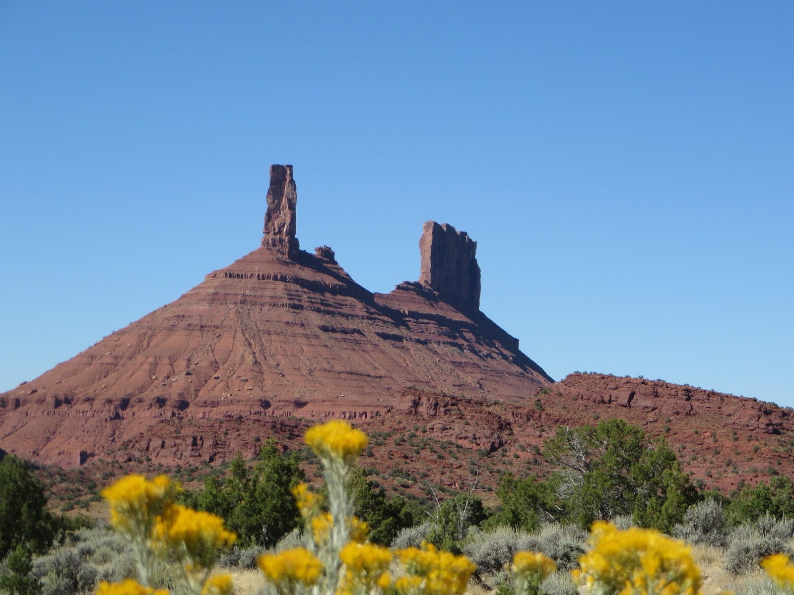
Another strategy that is working well is to drive to the far end of the park first. Then we work our way back to the front as everyone else comes into the park and starts at the first overlook.

So we drove to Devil's Garden. We came here yesterday near the end of our visit, just to check it out.
The parking lot was full to overflowing. A dozen or so cars parked in "No Parking" zones and 6 or so cruising around and around the lot trying to catch someone leaving.

This morning we were greeted by a raven who had found his "All You Can Eat Buffet."  He checked us out carefully but did not budge from his spot.


 The entrance to Devil's Garden is through what at this point in our travels we would call a "slot canyon."
We would learn later it was way to wide for that name.


 It still amazes us how fast the landscape changes. This is what we saw when we came out of the canyon.


Another local resident checking us out. Notice he didn't stop nibbling. And I don't know what the evil eye was all about. But I asked Carol not to photoshop it out because it looked authentic to me.


 "Landscape Arch". When we first saw it I thought we'd be scammed. There are lots of "starting of arches" that haven't broken through the far side yet. And that's exactly what this looked like to me. After a mile hike, I was not pleased.


 But when we got closer I saw the most fragile arch we were to see on the whole trip. Since 1991, three pieces of rock measuring 30', 47' and 70' feet have fallen to make the thinnest part. To quote one of the brochures, " It is hard to believe that a piece of rock like this can exist. In its thinnest section the arch is only 6 feet thick, yet it supports a span of rock 290 feet long. Indeed, this arch could collapse at any time: any day, any year, any decade, or any century." In its infinite wisdom, the NPS has closed the trail under the arch.


 In contrast to Landscape, Tunnel Arch.has a long life yet to live.


 So does Pine Tree Arch.


Skyline Arch.


On the way to Sand Dune Arch, we did walk through a "slot canyon."


Sand Dune Arch.


On the way out I was certain I heard, "You in trouble Dumb Dumb. You better Run Run." But then he winked and I knew it was OK.


Our last arch was Broken Arch. Named because although it is still standing, there is an obvious break right in the center.

Longer hike than I would have liked,  but fairly flat and still not hot.


One of many, many "balanced rocks."


Throughout my blog I have tried to put pictures in context by either telling you their names, like "Delicate Arch" or at least some definition. This next one, we are told, is one of the most photographed in the park. But the NPS has not named it.


Next we go to Canyonlands.

Friday, October 7, 2016

ARCHES NATIONAL PARK

We got an early start and were in the park by 7:30. The sun was just coming up over the mesa and it promised to be a wonderful day.  There are over 2000 arches in the park. We saw maybe 10 over our two day visit. The ones that required an overnight backpacking permit were not on our list.

Turret Arch.

The Windows.

 The South Window/

The South Window from the other side. After a long hike.


The North Window.

 The Double Arch.

Delicate Arch.

The wall in the background doesn't have a name because it isn't an arch. Yet. But it's going to be one in a few hundred thousand years.
After hiking and taking these pictures in the early morning sun we went back to the Airstream before noon. When we went in at 7:40 there was no line at the entrance. When we left at 11:30 there were over 40 cars in line.

A relaxing lunch and a nap for me. Then back into the park around 6pm for the sunset.   Again, as we went into the park we had no line. But dozens of cars were leaving. As long as the general mentality is, "Get up late. Get to Park mid-day. Stay through the heat of the day when the sun is overhead and washes out all the color. Go home at 5 or 6." Our system will work beautifully.  What the heck? It always worked at Disney World.

Everybody we ask told us that "The Fiery Furnace" was the best sunset spot.

They were right. Here are three pictures of one section, taken less 10 minutes apart.


Here are two of another view. Again, taken less than 10 minutes apart.


Then we had a long period of sunset and twilight.


We stopped at another location on the way out of the park to view the sky like no one back East has ever seen. Sorry, not a good enough camera to take a picture.

Up early tomorrow for another short day. We'll enjoy the empty spaces and early light and leave before the crowds get in.


Wednesday, October 5, 2016

ARCHES NATIIONAL PARK - NO, JUST LA SAL NATIONAL FOREST. ARCHES TO FOLLOW.


When we arrived at Pack Creek Campground in Moab the host said, "I was expecting you around Noon." I said, "We stopped in Green River to watch the PSU/Mich game. But we left in the third quarter because it just became to painful to watch." He replied, "OH MAN ! You should have stayed Penn State pulled it out in the fourth quarter."  I thought my immediate reaction was, "Yeah Right. No Way that happened." But he insisted that a flicker of belief crossed my face first. He then spent half an hour telling where to go and what to see both in and outside Arches.

So that afternoon we took his advice and headed to Sand Flats Road for a close up look at the La Sal National Forest and Castle Valley.  We took a little over 5 hours and drove almost 90 miles. About half horrible washboard dirt and half paved.

The mountains were topped with snow.


But the roads were clear.


A few miles later and we were "up close and personal" with the mountains. Other travelers told us is was only a short hike to the snow. We chose to take them at their word..


The aspens are starting to change color.


And they're especially beautiful when combined with Ponderosa Pines and  reflected in Oowah Lake, elevation 8800 ft.


Constant exposure has greatly lessened Carol's "passenger anxiety"


 We were told, "Be on the lookout for wildlife. Especially above 7000' elevation.

 The turkeys were two of a dozen or more. But they are very fast so this is all the evidence we have.


Remember those "Free Range" signs I mentioned in an early blog.

I almost hit this one. 


 Momma and calf.


Our campground friend told us which road to take off the mountain road to enter Castle Valley. He said, "When  you get the the Grand Canyon you will see that it truly is "Grand." But you will be able to say, I saw where it started. Because Castle Canyon IS the Colorado River."

Before we got there, we stopped at an overlook that promised "dinosaur tracks". Not a hyped commercial site, but a State Park.

The first couple took a little imagination.


But then they got pretty clear.


As promised, the views as we descended into Castle Canyon were incredible.

But when we got close to the Canyon floor and looked UP, things got even better.


So our first day where we came to see Arches and Canyonlands National Parks. We didn't go to either and Carol took over 200 pictures.

All because a friendly campground host decided to take a few minutes and talk with us.

God IS good.

Every Day.