Wednesday, October 19, 2016

KODACHROME BASIN STATE PARK

Will they change the name of this State Park soon?

In just a few years there will be no one alive who knows what "Kodachrome" was. And that will be a terrible shame. 

Because, "Momma don't take my Sim Card away." just doesn't have the same feeling.

For my OLD friends who "got" that reference  --  and for my young friends who need an education in good music, click here.

It was in 1948 that the National Geographic Society explored this area and named it for its spectacular colors. The State got permission from Kodak to keep the name when it became a state park.

Another major in between. Based on TripAdvisor and Campendium.com I REALLY wanted to camp there as the base for Bryce. They didn't have any spots available. BUT turns out it's 20+ miles to Bryce and the first 10 or so are 35 mph on the park entrance road. My second choice was Bryce Canyon Pines RV park which was 3 miles from the Park. Thank you Lord.

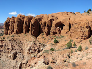
We did decide to drive to Kodachrome during our stay in the area. The big deal is the collection of  67 "pipes". These are monolithic stone spires. Although they are found in a few other places in the world, Kodachrome has many more of them than most locations. The scientists don't have a clue as to how they were formed. Wait. That's not completely accurate. Scientists say they do know. But there are three or four different groups of scientists who say they know. And they all have different theories.

The white layer of sandstone is the top layer in this area. It's only about 95 million y ears old.


 And some of the biggest spires are all white.


Others are red.


Some are both.


Carol thought this looked like a white wolf climbing thier red sandstone. Do you see him?


How about now? Click on it to see it enlarged.


At the end of the road was a Nature Trail. "Hard Surface 0.5 mile round trip. ADA accessible. Sounded good to me. Lots of interesting stuff about the plants and animals. Not so much for picture taking.

Next was "Angel's Palace Trail." Listed as "rising  150 ft. 1.5 mile. Easy/Moderate."  That didn't sound too bad either. It did offer spectacular views.

We're maybe half way up here. There's our Big Red Truck.


Unfortunately to get the  BEST pictures required walking this "neck" to an overlook. 


Which Carol did.


Then I guess we got to the "Moderate" part. What you can't see from here is that as the trail narrows, it slants to the canyon side and it's loose stone.


But we continued.

A Pipe that apparently has lost its white cap.


Interesting colors.


Some of the views they promised us.


My idea of a cairn.


So --- an "Easy/Moderate" done and it's still early in the day.

Let's try "Shakespeare Arch- Sentinel Trail".  "Easy to Shakespeare Arch. Moderate to Strenuous from there." "Gives the user magnificent views of Grand Staircase-Escalante National Monument."

OK, we'll do the "Easy" and see what the rest looks like.

 I guess we're going around this somehow.


 Nope. We're going UP it.


The Shakespeare Arch.

Another Pipe.


Miniature Arch ?


The trail did get a lot more "strenuous". But by the time we got to that part, we were way more than halfway around the loop. So we kept going.

And were rewarded with more views of the Escalante.


Enlarge this picture and look for the trail we had just been on a few minutes before.

HINT. It's on the left side of the picture.

And it's as narrow as it looks.


We were very glad to call it a day for hiking. The one last thing we wanted to see was "Chimney Rock". Which we could drive to. "Four wheel drive, high clearance vehicles recommended." HEY. It didn't say "required."

Here we are after several miles of bone jarring washboard dirt road.


I found a "fixer upper" but Carol doesn't want to settle here.


One last view as we leave the Park.


OK.. Two.


Tomorrow we head for Zion.

Sunday, October 16, 2016

BRYCE CANYON NATIONAL PARK

ONE MORE TIME. Not the last, I'm sure.  Our planned route took us from Torrey east and then straight south to Bryce on US89. But NOOOOO.  Moab RV manager said that Scenic Route 12 was a must do. After he asked if we were "mountain road" comfortable. I said that Carol could be a little nervous but she had done fine through the Bighorn Mountains on Rt 14.  He assured us it was no worse than that so off we went.

Our DeLorme map program said, "116 miles, 3 hrs and 20 minutes." Without stopping.  For my math challenged friends, that's about 35 mph average on a paved State highway.

This was not the first thing we saw, because we started out going UP, but it'll give you an idea of the ride we had. Elevation on the route went from 5223 to 9636.


The trip took us almost 6 hours. We were stopped at overlooks almost as much as we were driving.


 Our view as we ate lunch.


I've been teasing Carol about taking pictures of chipmunks almost everywhere we've been. "We have those at home,  you know." They're so cute she doesn't care.

This is a special one because he was certain he was hiding in that bush.


No names or titles, just some fantastic pictures.

HAD to show you these. Cattle grazing at over 9000 ft elevation.


The Aspens have been beautiful since Grand Tetons but they are especially pretty when mixed in with the Ponderosa pine.

We've seen trail markers and cairns. But this was the most creative. They started building on the edge of that bottom rock.


It's amazing what a little water will do in the desert.

Those are cottonwood trees. And there is shade and moisture and plants that love both under them.


In 1897 a group of Mormons gathered about 40 miles east of Escalante, UT to make their way on a trail they would build to the San Juan Valley. Scouts had said it could be done. Other scouts said it was impossible. It was the most incredible feat of engineering by unskilled hand labor imaginable.

They found a very narrow canyon down to the Colorado and blasted it wide enough to get wagons through. Here is a first hand account of the first wagon to descend, " "If you ever come this way it will scare you to death to look down it. It is about a mile from the top down to the river and it is almost straight down, the cliffs on each side are five hundred ft. high and there is just room enough for a wagon to go down. It nearly scared me to death. The first wagon I saw go down they put the brake on and rough locked the hind wheels and had a big rope fastened to the wagon and about ten men holding back on it and then they went down like they would smash everything. I'll never forget that day. When we was walking down Willie looked back and cried and asked me how we would get back home."

They reached a point where there was simply no way to go down or cross a shear cliff face. Here is an historical marker that explains what they did.


Driving the highway didn't seem so bad after reading that.

The first thing we learned was that Bryce Canyon was not a canyon. It's called a series of amphitheaters along the eastern side of the Paunsaugunt Plateau. More simply put, it's like one side of a canyon.

The plateau ranges from 8000 to 9000 feet elevation and the views are from the top looking down and out over the formations.

The scenic road through the park is 18 miles long.. Our usual plan to "drive straight to the end" and stop at overlooks and trails on the way back was especially fitting in Bryce because all of the overlooks are on the right side of the road on your return trip. Although it wasn't "summer crowded", the traffic was quite heavy so all right turns into and out of parking areas really made sense.


This is the southern end of the road.


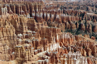
The views and especially the "HooDoo's" just keep getting better and better as we move north from overlook to overlook.


 I may not add one to every post, but this one was too cute to skip over.


Our decision to drive to the south end and stop at overlooks at we returned not only kept us out of the biggest crowds, but it allowed the views to just keep getting better.


Literally thousands of formations in this one relatively small area. Pure white freshwater limestone at the highest points and red limestone underneath. Most of the softer white is eroded away.


The last two vistas are "Sunrise Point" and Sunset Point." We didn't make sunrise so we returned for sunset.

But again following advice of locals, we returned to Inspiration Point for these pictures.


Another end to another wonderful day. These Parks have so much to see we could spend a month at each. But we are so Blessed to be able to do what we have. And there's LOTS more to come. Tomorrow we'll back track slightly to visit Kodachrome Basin State Park.  On to Zion  after that and then the Biggie! North and South Rim of the Grand Canyon, with lots of amazing scenery along the drives between them.